Destination hiking route to Hahnenklee via the Altarklippen


- 2:10 h
- 7.09 km
- 261 m
- 40 m
- 302 m
- 558 m
- 256 m
- Start: Parking lot campsite at Krähenberg - street Am Mauerkamp
- Destination: Hahnenklee
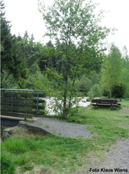
Scenic hiking route 2V past the campsite, Taternplatz, Grüner Weg, Altarklippen. There is stamp point 171 - Altarklippen with a view of the Granetalsperre and Goslar. The view is considered one of the most beautiful viewpoints of the northern Harz. From there, continue on route 2S with a wonderful view of the Harz mountains to the junction Rolle. From there, many hiking routes to Hahnenklee are possible. Distance to the town center approx. 3 km. Along the route there are 2 shelters.

Good to know
Best to visit
Equipment
Normal sturdy footwear
Directions & Parking facilities
A7 exit Rhüden - B82 exit Langelsheim, K35 towards Wolfshagen
Start at the public parking lot Campsite at Krähenberg - street Am Mauerkamp, Wolfshagen im Harz
Center of Wolfshagen, street “Die Meine” or “Triftweg corner Rübekamp”
Literature
More detailed route description on the Harzklub website www.harzklub-wolfshagen.de
Author´s Tip / Recommendation of the author
From Hahnenklee, there are several routes that lead back to the starting point. The waymarking of the paths is good. However, it is recommended to carry a hiking map.
Map
Nearby