Circular route in the Gande valley (RW5)

10.13 km long
Difficulty: easy
Walking / hiking
  • 3:00 h
  • 10.13 km
  • 149 m
  • 151 m
  • 109 m
  • 195 m
  • 86 m
  • Start: Parking lot Hildesheimer Straße (spa area) (127 m) Coordinates: Geographic 51.874466 N 10.033894 E UTM 32U 571174 5747581
  • Destination: Same as start
The path initially leads through the Lahberg landscape conservation area and then reaches Orxhausen in the Gande valley. From there, it goes through the forest on the south side of the Wadenberg back to the town.

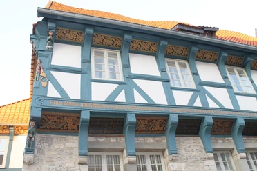
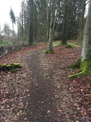
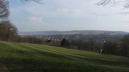
Before the path reaches our first destination, the Lahberg landscape conservation area, it offers an opportunity to get to know the historic old town of Bad Gandersheim a little. From Lahberg, the view then extends over the typical, gently hilly cultural landscape of the Harz foreland. From here, we can already see our next destination, the small village of Orxhausen. It lies picturesquely on the Gande, which meanders in many loops through the valley here. After leaving the village, the path ascends a bit on the edge of the forest on the Wadenberg. Before we enter the forest, it is worth looking back to enjoy the beautiful distant view. Initially through the magnificent deciduous forest and later through the fields, our route soon reaches the town again.

Good to know

Best to visit

suitable
Depends on weather

Directions

The path begins behind the information board on Hildesheimer Straße. It initially follows the RW 5 trail markers in the proposed hiking direction to the edge of the nearby parking lot. Before the small Gande bridge, we keep to the right, cross Roswithastraße, and quickly reach Hildesheimer Straße through a small park. From here, continue left towards the town center. Via the market square, you reach Moritzstraße, which becomes Northeimer Straße after the railway underpass. We follow it further uphill until a narrow path leads to Lahberg on the right. The trail markers then guide us to a bridge crossing the federal road. Immediately behind the bridge on the right is a scenic field path, on which we stay until the next fork. We keep right and walk on a grassy path through the lovely dry grassland Lahberg. Shortly after, our path meets Neue Straße, which we then follow left to a small group of houses. In front of the buildings, our path turns right, bypasses the houses in a wide left curve, and reaches Orxhausen, always accompanied by the railway line. At the village entrance, we stay right and follow Dorfstraße to the railway crossing, then immediately cross B64 to the 'Grüner Jäger.' There is a place to eat at Dervish in Grüner Jäger (www.gasthausdervish.com). If you prefer to rest surrounded by greenery, you should use the versatile sports and leisure area of the pretty village beforehand for a break. After the pause, the path goes from the 'Grüner Jäger' into the forest, where it soon meets a forest road, which we follow right to the edge of the forest. At the next fork, you can choose. Those who follow the signs of RW 6 reach their destination via the idyllic floodplain of the Mahmilch and the magnificent Cluswald. This path is a bit longer but much more varied than RW 5. Those who choose the original path continue straight ahead and quickly, but less spectacularly, reach the starting point. © T. and H. Schrader

Directions & Parking facilities

Arrival by car

From the south: A7 towards Hannover, exit 68 Echte, direction B445 Bad Gandersheim/Kreiensen.

From the north: A7 towards Kassel, exit 67 Seesen/Harz, direction Seesen/Osterode/Bad Gandersheim.

Free parking at the start

Arrival by train

From Hannover: Metronom to Kreiensen. Change to the regional train to Bad Harzburg. From Göttingen: Metronom to Kreiensen. Change to the regional train to Bad Harzburg.

Literature

Here is a detailed route description with hiking variations: https://www.bad-gandersheim.de/kultur-tourismus/wandern/rundwanderwege/ 

Safety guidelines

Trail marker: Red 5 on white background

Map

Bike and hiking map Bad Gandersheim scale 1:25,000

Latest maps are sold at the Bad Gandersheim tourist information

Nearby