Goslar - Hahnenklee hiking route to the UNESCO World Heritage Rammelsberg Goslar

- 4:00 h
- 13.55 km
- 194 m
- 479 m
- 282 m
- 756 m
- 474 m
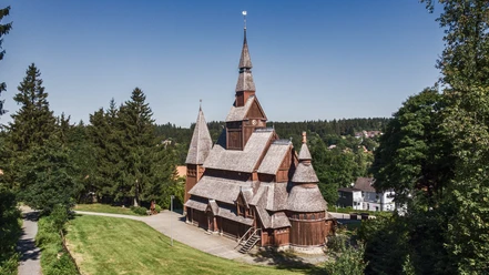
- Start: Large parking lot at the Stave Church
- Destination: UNESCO World Heritage Rammelsberg Mine and Old Town of Goslar
The starting point for this hike is the “large parking lot at the Stave Church.” At the parking lot, you will find a sign from the Harz Club marking the “Upper Auerhahn Trail” (5C/1E triangle with red dot). You follow the “Upper Auerhahn Trail” towards “Auerhahn” and cross the federal road L241. The steadily ascending access road “5D green triangle” leads you to the 762 meter high “Schalke” (stamp point 125). Further on the path, you reach a fork where you keep left and follow the course until you come left to the turnoff “Schalker Weg” “1F red triangle” towards Goslar. You keep slightly right and walk through several curves always along the forest path beneath steep slopes below the “Großer Schleifsteinsberg.” Time and again you catch brief glimpses into the “Wintertal” below you. Soon you come to the “Volksbank Hut” at a large fork with several paths. This offers a good opportunity for a short break; afterwards, you go left past the shelter and, by turning right, use the slightly lower “Herzbergerweg.” The “Herzbergerweg” leads around the “Herzberg” directly to the former forest swimming pool “Herzberger Teich” in Goslar. This path offers fantastic views over the “Gosetal,” Goslar’s mountain meadows, and Goslar itself. Before you reach the “Herzberger Teich,” you come to a fork; here you keep slightly left and stay on the “Herzbergerweg.” Around the “Herzberger Teich,” the road leads you to the “UNESCO World Heritage Rammelsberg” – Museum and Visitor Mine (stamp point 91), the destination of this hike. For the way back you take bus line 830 from “Clausthaler Straße” towards Hahnenklee.

Good to know
Best to visit
Directions & Parking facilities
- B 241 from the direction Goslar/ Auerhahn/ Kreuzeck/ Clausthal-Zellerfeld
- L516 from the direction Hannover/ Seesen/ Lautenthal
RBB Bus: Line 832 Goslar - Langelsheim - Wolfshagen (Lautenthal - Hahnenklee)
Stop: Hahnenklee Treff Hotel or Cemetery
Additional information
HAHNENKLEE tourism marketing gmbh
Kurhausweg 7, 38644 Goslar-Hahnenklee
Tel. 05325 51040
E-Mail: info@hahnenklee.de
Literature
Author´s Tip / Recommendation of the author
Nearby