Karstwanderweg – Circular route 7 around Steigerthal

- 1:15 h
- 4.64 km
- 86 m
- 87 m
- 228 m
- 314 m
- 86 m
- Start: In Steigerthal, on the eastern edge of the village with the sports and playground at the southern foot of the Schellenberg.
- Destination: In Steigerthal, on the eastern edge of the village with the sports and playground at the southern foot of the Schellenberg.
The route on the Karstwanderweg first leads northwest and then south straight through the village. It turns right in the meadow area and then at the edge of the forest and continues along the Karstwanderweg through the karst landscape of the Haselhai.
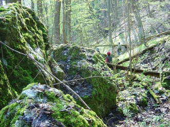
In the Haselhai, the Buntsandstein overlies the karstifiable sulfate rocks of the Zechstein. Water-retaining clay layers in the lowermost Buntsandstein form the basis for the formation of spring horizons. The unsaturated water of many small springs finds an underground outlet in the gypsum. The dissolution of the gypsum causes solution dolines to form. Due to the constant displacement of sinkholes, doline is lined up after doline. Thus, doline valleys or uvalas were formed. Three well-formed uvalas with many single dolines merge in the Haselhai area and discharge the surface water underground towards the Krummbachtal. Deposited Zechstein clays have made some dolines impermeable to water. This has created waterlogged and water-filled hollow forms in the form of shallow ponds. In the Haselhai area, many single dolines have developed, some of which are still active today.
The further path now leads into the open landscape and from the fork continues to the right to the northeast to the Glockensteine (stamp point HWN No. 198 with information board). These are late medieval atonement crosses. They were erected for people who died suddenly and unprepared (without last rites). The majority of these stone crosses are former murder and atonement crosses, erected in memory of a killed or accident victim. A legend about the stones says that a bell founder from Stolberg killed his journeyman here, whose bell casting was better than his own.
A detour northwest on the Karstwanderweg leads to the information board "Blick Helmetal" with a distant view to the Kyffhäuser and the Goldene Aue. About 600 meters further northwest, the detour leads to the natural monument Pfaffenköpfe with species-rich dry grasslands on a structurally rich gypsum hill landscape. The return route goes back again over the Glockensteine and northeast to Steigerthal.

Good to know
Best to visit
Directions & Parking facilities
Parking lot in Steigerthal
Additional information
Map
Nearby
Download GPX file