At the Schanze (RW 3)


- 1:27 h
- 4.82 km
- 137 m
- 137 m
- 124 m
- 259 m
- 135 m
- Start: Information board at the parking lot on Hildesheimer Str. (N 51°52.479´ E10°02.020´) Hildesheimer Str.
- Destination: Like start
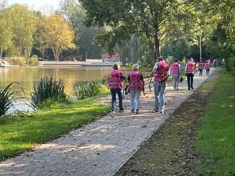
A short forest hike on the Schanze ridge, especially recommended on hot summer days. Wild garlic, sweet woodruff and wood anemones characterize this path in spring. At the Schanze, information boards provide details about historical and geological features. If you like, you can descend to nearby Wolperode for refreshments (1.2 km).

Good to know
Pavements
Best to visit
Directions
The path begins at the information board on Hildesheimer Straße. We first follow the "3" in the suggested walking direction to the edge of the nearby parking lot. Here we cross the Gande on a small bridge and walk upstream. By the third bridge at the latest, we switch back to the left side of the brook and continue walking alongside it. In a valley, our path then ascends and reaches a developed forest road at the top, which we follow a short distance to the right. Soon a trail sign shows that it goes sharply uphill again to the left on a path. At the top, a bench next to the water reservoir invites you to rest. It’s more enjoyable if you take the opportunity here to descend to the nearby Wolperode for refreshments (15 minutes). A signpost opposite the bench indicates the direction.
The actual path turns west before the water reservoir and climbs moderately a short distance further onto the ridge of the Schanze. Before that, a sign points to a nearby shelter. Soon it goes downhill to a forest road above the city. The road is crossed, and on a somewhat bumpy forest path, we quickly reach the city outskirts. The trail markers guide us safely the last stretch back to the nearby starting point.
Directions & Parking facilities
From the south: A 7 towards Hanover, exit 68 Echte, direction B 445 Bad Gandersheim/Kreiensen.
From the north: A 7 towards Kassel, exit 67 Seesen/Harz, direction Seesen/Osterode/Bad Gandersheim.
Author´s Tip / Recommendation of the author
Safety guidelines
Map
Bike and hiking map Bad Gandersheim 1: 25,000
available at the Tourist Information of the city of Bad Gandersheim
Price: €3.50
Nearby


Download GPX file