Circular hiking route 3

- 2:00 h
- 6.99 km
- 168 m
- 168 m
- 254 m
- 427 m
- 173 m
- Start: Car park Triftweg - corner Kreuzallee
- Destination: Car park Triftweg - corner Kreuzallee
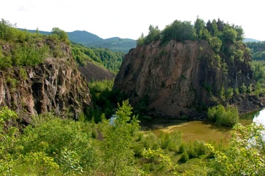
Beautiful route with views of the Harz mountains, the village of Wolfshagen, and its diabase quarry. Clubhouse of the Harzklub ZwgV. Wolfshagen is passed. Open for hiking groups on request and partly on Sundays in good weather. Inquiries at the Tourist Info, Wolfshagen in the Harz. Tel. 05326-4088


Good to know
Best to visit
- suitableDepends on weather
Equipment
Normal footwear
Directions & Parking facilities
- Getting there
A7 exit Rhüden - B82 exit Langelsheim, K35 towards Wolfshagen
ParkingStart opposite the parking lot. At the Harzklub clubhouse "Schäderbaude".
Public transportationStop - Triftweg / Rübekamp - In the village of Wolfshagen
Additional information
Tourist Information
Im Tölletal 21
38685 Wolfshagen in the Harz
Tel. 05326 4088
info@wolfshagen.de
www.wolfshagen.de
www.harzklub-wolfshagen.deLiterature
More detailed route description on the Harzklub website www.harzklub-wolfshagen.de
Author´s Tip / Recommendation of the author
Wolfshagen has excellent gastronomy. In the Harzklub hiking map "Hiking between Innerste and Granetalsperre", all hotels, restaurants, cafes, and presentations are marked. Map available in all hotels and the Tourist Info.
Safety guidelines
Not passable by car
Map
Local map by Harzklub ZwgV. Wolfshagen "Hiking between Innerste and Granetalsperre" 1:15000. 10 hiking routes are described in detail. Many infos on the back of the map
Nearby
Download GPX file