From Oderbrück around the Oderteich

- 1:35 h
- 6.42 km
- 68 m
- 69 m
- 719 m
- 788 m
- 69 m
- Start: Parking lot and bus stop Oderbrück
- Destination: as starting point, alternative destination: dam of the Oderteich (parking lot + bus stop)
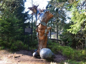
The start of the route is at the parking lots of the Oderbrück settlement. There is also a bus stop for the hourly Braunlage - Torfhaus - Bad Harzburg line. West of the federal highway, we follow the course of the Oder river gently downhill toward Oderteich. At a junction, we turn right. The path becomes narrower and is soon bordered with granite stones. At the northernmost point of the Oderteich, a romantic spot invites you to rest. Here is also the stamp station #217 "Sonnenkappe" of the Harzer Wandernadel (Harz hiking badge). We then head south, leaving the Oderteich at some distance on our left but always in sight. Shortly before reaching the dam and the federal highway on it, a small detour left to the shore of the Oderteich is worthwhile, where swimming is possible in summer. At the Oderteich parking lot, there is another bus stop. From here, you can travel directly to St. Andreasberg or Braunlage. By transferring once near the B4, you can return by bus to Oderbrück. The return path on the eastern side of the Oderteich is not barrier-free and is only suitable for sure-footed hikers. Therefore, taking the bus back to the starting point is often a more pleasant alternative. The now following difficult section leads over wooden planks and very stony passages across raised bog areas; however, it compensates with great views over the Oderteich and absolutely natural forest areas. At the next junction, we turn right and follow the now wider path until we reach the federal highway. The last few meters back to the starting point lead along the edge. In Oderbrück, the "Kaffeeklappe" invites you to a small snack in the outdoor area.

Good to know
Pavements
- Path (11%)Asphalt (5%)Street (1%)Trail (59%)Gravel (24%)
Best to visit
- suitableDepends on weather
Directions
For better orientation, follow the following trail markings:
From Oderbrück, hiking trail 9C (blue horizontal marking), which then leads into the "Rundweg Oderteich" (Oderteich circular route), which you follow counterclockwise. The difficult section east of the dam is marked, among other things, with the "Harzer Hexenstieg" symbol. Attention: shortly after leaving the shore path, do not follow the markings at the next junction, but turn right following the "Oderbrück" signposts.
Equipment
- Secure footwear required as often damp and muddy sections must be walked. Also many stony and rocky path sections.
Directions & Parking facilities
- Getting thereArrival by car via the B4 to Oderbrück or the B242 to Oderteich.Parking
Good parking options in Oderbrück,
Limited parking resources at the Oderteich parking lot.
Public transportationFrom Bad Harzburg, Torfhaus, and from Braunlage with line 820 of the KVG Braunschweig to the Oderbrück stop.
Also with line 820 of the KVG Braunschweig to the Oderteich stop directly from St. Andreasberg and Braunlage.
Timetable: Line 820 KVG
Additional information
Author´s Tip / Recommendation of the author
The route is located in the Harz National Park. It provides the following information about the paths around the Oderteich:
During your hike, you will go through all phases of forest succession. Areas where spruces have just died alternate with young wild forest where spruces and rowans have already grown man-high between the deadwood without human intervention. The young forest generation will make the forest richer in species and structure than it was before.
Over time, a valuable flora and fauna has settled on the shore of the Oderteich. For birds such as the grey wagtail, the shore is an important habitat. The river sandpiper is also sometimes seen here. Entry to the shore areas is therefore only permitted in the lying and bathing area. Please observe the signs and do not leave the marked paths.
Safety guidelines
Our hike has no significant climbs but is not suitable for wheelchairs and strollers due to stony and root-rich path sections.
On the east bank, after a stony and root-rich section, you will reach a boardwalk that leads you dry-footed over a peat area. Specialists adapted to the wet peat location grow here. Many mosses can be found, as well as round-leaved sundews and cotton sedge. Please do not leave the boardwalk to protect the sensitive habitat.
Nearby
Download GPX file