Natura Tip 15 - Staufenberg and South Harz near Zorge


- 3:05 h
- 9.92 km
- 306 m
- 306 m
- 323 m
- 565 m
- 242 m
- Start: Confluence of the Elsbach into the Zorge
- Destination: Confluence of the Elsbach into the Zorge

Good to know
Pavements
Best to visit
Directions
From Zorge...
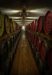
Where the Elsbach flows into the Zorge is the starting point of our hike. Zorge initially means the left tributary of the Helme, which forms within the place of the same name from the confluence of the Sprakel and Wolfsbach streams. The source of the Großer Wolfsbach lies at 569 m above sea level in the Hohegeiß 5 km away. Already 230 metres of elevation are overcome on this short stretch to the Elsbach confluence in Zorge at 339 m above sea level! People here in the valley always lived in Sorge (worry/fear) that the Felsenbach (German Szurgenge) would become a raging river during heavy rains. This might explain the name of the place belonging to the Walkenried municipality. Until the end of the Second World War, the name Zorge was also found in the Reich course book because since 1907 the standard gauge narrow-gauge railway Ellrich – Zorge ensured connection to the supraregional railway network. The border zone from 1945 prevented the continuation of the line. From 1965 to 1967, the tracks from Unterzorge to Zorge were finally dismantled. The station building at the terminus Zorge (South Harz) still exists. We use the parking lot there as the starting point for our hikes into the FFH and bird protection area. We do not immediately console ourselves for the loss of the railway with a whisky, even if the temptation is great! The Elsbach coming from the FFH and bird protection area gave its name to the Harz single malt whisky. The distillery and spirits manufactory are located in the former Kurhaus building next to the parking lot. The name "Hammerschmiede" (hammer forge) is a reference to the barrel storage of the family company in the buildings of the former Wieda ironworks. We leave the tempting barrels on the right and instead hike uphill in the Elsbach valley towards Stiefmutter.
...via the Stiefmutter...
We hike the Harzklub hiking trail 32 Thale-Benneckenstein-Zorge-Walkenried, whose 6.9 km long section connects the Ellrich station in Thuringia via Roter Schuß and Staufenberg with the former Zorge station, up to the Stiefmutter trail junction. About 100 m from there is the stamp point no. 164 of the Harzer Wandernadel in the shelter. Here we have a view of the Hundertmorgenwiese, which we will circumnavigate extensively. The name of the meadow indicates its former size. "Morgen" is an old unit of area. It corresponds to a quarter of a hectare. The originally approximately 25 ha meadow was created to supply the cattle kept in Zorge with hay in winter. In the 1920s and 30s, ski descents and even ski jumping were held on the meadow by the local winter sports club. Later, in the 1960s and 70s, the meadow was mown or grazed no more than once or twice a year; it became fallow. Young trees, mostly spruces, spread out. Only in the following decades did the Lower Saxony State Forestry free the former mountain meadow again. In cooperation with regional farmers, the Hundertmorgenwiese is now used extensively as cattle pasture. Thanks to this commitment, we still find here today a species-rich gem with 35 plant species from Lower Saxony’s Red List. Geologically, the Hundertmorgenwiese is in the area of the Lower Rotliegend (Permian, older than 258 million years). The weathered reddish rocks, mainly consisting of sand and volcanic ashes, form a firm mud when wet. In Low German, it is called "Steife Modder" (stiff mud), which is said to be the origin of the place name "Stiefmutter" (stepmother).
...to the Harz Border Trail
We go the short way back to the Stiefmutter trail junction. From there a narrow path branches off to the Harz Border Trail, which here runs on the same route as the theme route Historical Borders. A detour to the probably very old two-country oak is highly recommended! Its two trunks, one reaching into Thuringia, the other into Lower Saxony, originate from suckers. They root together directly on the state border, a historically much older border. The last border stone set here bears the letters DDR on one side. The opposite side remained uninscribed because the Federal Republic of Germany at that time did not want to recognize the inner-German border as the border of two independent German states. It is decades ago now that this border lost its terror. On the DDR side it was strictly guarded. The existing wealth gap from west to east and the desire for freedom of many East Germans repeatedly led to escape attempts. Most of these, however, failed. Even in the far hinterland of the DDR, travellers towards the western border were monitored. Along the border there was a large restricted area which could only be entered with a pass. This included Rothesütte and Sülzhayn, the closest places in Thuringia. Even closer to the border was the so-called protective strip. It was fenced with an alarm wire. If the alarm was triggered, additional forces of the DDR border troops were immediately called in. They patrolled on the patrol path, followed by a traces strip, a 3 m high expanded metal fence and further barriers. Then came the "no-man’s land" where the old DDR concrete border pillar still stands today.
Back to the starting point
From the two-country oak, we now return along the Harz Border Trail and continue towards the Wendeleiche. The Harz Border Trail here is part of the theme route "Harz without Borders. Along historical border paths through nature and history." Our path breathes history at every step. At intervals sometimes less than 20 m, continuously numbered border stones stand. The letters KP (Kingdom of Prussia) point towards Thuringia. From the Lower Saxony side, the stones show the letters HB (Duchy of Brunswick). When these stones, which mark the exact course of the border by an additional engraving, were set from 1816, older border stones were laid down. These roughly hewn stones from the 18th century can still be found. They marked the border course of the Walkenried monastery office (StW) to the County of Hohnstein. In 1593 the territory of the Walkenried monastery fell to the dukes of Brunswick and Lüneburg. Those who hike with sharp eyes can still discover oak posts from the first border fence which separated the Soviet occupation zone from western Germany. At the Wendeleiche we reach the stamp point no. 165 of the Harzer Wandernadel (shelter). Iron rings on the trunk of the oak are remains of a spiral staircase to a viewing platform inaugurated here in 1901. Next, we continue to the mysteriously shrouded place of the Pregnant Maiden. Does this really only mean the strangely shaped border stone? Anyway, here we leave the Harz Border Trail and descend to the Hundertmorgenwiese. We let our gaze wander into the distance and among other sights discover the Brocken. Eastwards, we walk around the Hundertmorgenwiese and finally along the Elsbach back to the starting point of our hike.
Directions & Parking facilities
Elsbach parking lot.
Additional information
https://www.harzregion.de/de/natura-tipp-broschueren-und-informationstafeln.html
Tourist Information Walkenried
Steinweg 4
37445 Walkenried
Tel: 05525 998900 0
info@walkenried-tourismus.de
www.walkenried-tourismus.de
Nearby


Download GPX file