- 1:45 h
- 6.32 km
- 137 m
- 136 m
- 284 m
- 384 m
- 100 m
- Start: Parking lot "Am Krähenberg" directly at the Wölfi-Bad, Wolfshagen in the Harz
- Destination: Parking lot "Am Krähenberg" directly at the Wölfi-Bad, Wolfshagen in the Harz
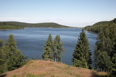
Scenic natural path, partly running along the Försterstieg. Midway with a beautiful view of the "Granestausee". Detour to the dam 500 meters and next to it the Harz waterworks. There are exhibition rooms with lots of information about water distribution around the historic and UNESCO World Heritage Harz water management system. Guided tours for groups with prior registration at the Harz waterworks.


Best to visit
- suitableDepends on weather
Equipment
Regular footwear
Directions & Parking facilities
- Getting there
K35 to the outskirts of Wolfshagen (coming from Langelsheim), turn left into "Kreuzallee" street, stay on the street past the crossing "Am Borbergsbach" until the end. On the left, a large parking lot with a hiking information board.
ParkingStart and end at the public parking lot "Am Krähenberg", Wolfshagen in the Harz
Public transportationBus stop - Wolfshagen street: Triftweg
Additional information
Tourist Information
Im Tölletal 21
38685 Wolfshagen in the Harz
Tel. 05326 4088
info@wolfshagen.de
www.wolfshagen.de
www.harzklub-wolfshagen.deLiterature
More detailed route description at the Harzklub website www.harzklub-wolfshagen.de
Author´s Tip / Recommendation of the author
Wolfshagen has excellent gastronomy. The Harzklub hiking map "Hiking between Innerste and Granetalsperre" shows all hotels, restaurants, cafés, and presentations. The map is available at all hotels and the tourist information center.
Map
Local map from Harzklub ZwgV. Wolfshagen "Hiking between Innerste and Granetalsperre" 1:15000. 10 hiking trails are described in detail. Many infos on the back of the map.