Harz Border Trail on the Green Belt

- 22:30 h
- 91.04 km
- 1,596 m
- 1,471 m
- 97 m
- 1,141 m
- 1,044 m
- Start: Rhoden Border Tower at Fallstein
- Destination: Tettenborn/Bad Sachsa Border Museum
The Harz Border Trail on the Green Belt, which for the most part runs directly along secluded border paths or the former “patrol road” along the former inner-German border, uniquely connects the nature, culture, and history of the Harz.
It crosses the mountain range on a varied and partly challenging hiking route between the Rhoden Border Tower (Osterwieck) in the north and the Border Museum Tettenborn (Bad Sachsa) in the south.
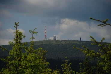
Along the way, you experience German contemporary history up close. Through the Ecker Valley, for many years a border river, the path winds along the Ecker reservoir – through the middle of which the border also ran – up to the Brocken. Past the Triangular Post, a historic three-country boundary stone, it goes below the Wurmberg to the border opening memorial stone between Braunlage and Elend. Relics of the German division are preserved at the open-air border museum near Sorge. The Ring of Remembrance and the three-country boundary stone at Jägerfleck near Benneckenstein are contemporary border markers on the way to Walkenried Abbey, which provides a fascinating insight into the importance of the Cistercians for the development of the region.
The Harzklub has completely equipped the trail with new signage. Information boards explain protected biotopes and historic sites along the path. For those who want to know more precisely, specially trained hiking guides offer guided tours. Specialized travel operators also organize luggage-free hikes over various stages along the Harz Border Trail.

Good to know
Best to visit
Directions
From the former Rhoden Border Tower in the north, the Harz Border Trail leads you on a varied and challenging hiking route over the Oker floodplain through the Ecker Valley, right through the national park up to the Brocken, past the Wurmberg, through mountain meadows and stream valleys to Walkenried and into the southern Harz gypsum karst landscape. It ends at the Border Museum in Tettenborn, a district of Bad Sachsa.
Additional information
For further information please contact:
Harzklub e.V.
Bahnhofstr. 5a
38678 Clausthal-Zellerfeld
info@harzklub.de
www.harzklub.de
Author´s Tip / Recommendation of the author
Packages from "Hiking in the Harz" for the Harz Border Trail.
From Ilsenburg on the Harz Border Trail - 3 stages - 4 nights from €430 per person in a double room
From Bad Harzburg on the Harz Border Trail - with or without overnight stay on the Brocken from €445 per person in a double room
Map
Nearby