L3 Red Cliffs Route


- 2:30 h
- 24.08 km
- 469 m
- 469 m
- 211 m
- 501 m
- 290 m
- Start: Wolfshagen outdoor pool, Am Borbergsbach 82, 38685 Wolfshagen im Harz. Starting the route also possible at: Tourist Information, Kaspar-Bitter-Straße 7 B, 38685 Lautenthal
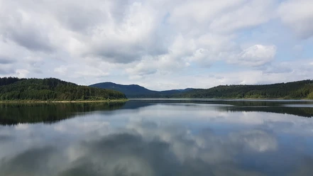
The easy hill and valley route includes two longer climbs, with the longest one to be tackled right at the beginning. Technically, a few sections are a bit more challenging, but still manageable for less experienced riders. Above the Innerste dam up to the northern edge of the Harz, several cliffs with their viewpoints invite you to take a break.

Good to know
Pavements
- Asphalt (16%)Gravel (76%)Trail (6%)Street (2%)
Best to visit
- suitableDepends on weather
Directions & Parking facilities
- Public transportationNot far from the train station, you can start the MTB routes L2, L3, and L4 at the southern town exit towards Wolfshagen.
Additional information
The Volksbank Arena Harz is also available on YouTube.
Map
The Harz for Mountain Bikers
Through the extremely varied North German low mountain range landscape, there are 74 signposted mountain bike loop routes (total length 2,300 km), classified into three difficulty levels. Official map set "The Harz for Mountain Bikers." Completely revised and expanded new edition. The new map set consists of a route book with detachable individual descriptions and detailed maps of the routes. There is also a topographic overview map (1:50,000) made of weatherproof and durable POLYART material.
ISBN 978-3-935806-28-2
Price 16.80 €
Publisher map solutions, Karlsruhe 2017
Nearby

Download GPX file