World Heritage Discovery Hike: Mining Traces at Rammelsberg


- 2:05 h
- 5.97 km
- 281 m
- 281 m
- 321 m
- 602 m
- 281 m
- Start: World Heritage Rammelsberg
- Destination: World Heritage Rammelsberg
Tip: Activate the audio guide mode in the app. At 9 stations you will learn interesting details about the Rammelsberg and the surrounding landscape.
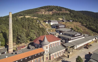
Discover on this 6 km circular hike the landscape changed by mining at Rammelsberg. Around the museum and visitor mine Rammelsberg in Goslar, you can still find many traces from the mining era in the landscape. Sometimes these traces are only visible at second glance.
You can start your hike at the gates of the mine and take the circular route up to the Rammelsberg. Along the way, discover old shafts, learn why a mine needed its own pond, and find out how the miners used to live.

Good to know
Pavements
Best to visit
Directions
You start at the World Heritage Site Rammelsberg in Goslar and follow the slightly uphill road "Bergtal." Here you will see the former miners' houses, the old mining office, and the former mining inspection. Follow the path a little further to the mouth of the Roeder tunnel and then go a bit further to the Herzberger Pond. Follow the path along the pond and then take the next left turn uphill. You now reach the Schmiedeweg (follow the signs: direction Maltermeisterturm) and walk uphill to Borchersweg. Upon arrival, keep left and continue on the path to the Maltermeisterturm. A little further on, you can view the Winklerwetter Shaft. Then go back a bit and take the steep forest path to the Gaipel Plateau where you reach the Communions Quarry. Please stay on the designated paths in this area. You now go up the steep rock ridge to Ramseck, where you have a great view over the town. Now continue a bit further to the highest point of the hike at the Waldschratt Hut. From here, take the downhill Borchersweg towards Rammelsberg Mine / City of Goslar. After 1.8 km you will meet the Schmiedeweg again, which leads you downhill back to the starting point of the hike.
Equipment
We recommend sturdy footwear for the hike.
Directions & Parking facilities
The town of Goslar, located in the middle of Germany, is easily accessible by car.
- Motorway A7: from the Rhüden exit onto B82 towards Goslar
- Motorway A395 / B6: from Braunschweig or Wernigerode to the B6 junction towards Goslar, B6 exit Goslar center
- Federal road 241: coming from Clausthal-Zellerfeld towards Goslar
- Coordinates: 51.890530739881231, 10.418005739009093
There are parking spaces for cars and buses in the immediate vicinity of the facility.
Additionally, two parking spaces for wheelchair users are designated close to the entrance.
Goslar station is served hourly by trains from Göttingen, Hannover, Braunschweig, and Halle/Saale.
- City bus line 803: From the station, you can reach Rammelsberg by city bus (every 30 minutes) towards the final stop "Bergbaumuseum." The bus stop is located directly at the station forecourt.
- The World Heritage Shuttle (line 809): Between the old town of Goslar and the Rammelsberg mine, a bus shuttle runs daily (every 30 minutes). Stop "Bergbaumuseum."
Literature
Hans-Georg Dettmer: Mining traces at every step. 30 reasons to hike the Rammelsberg. Ed.: World Heritage Rammelsberg (= Rammelsberg Guide. Volume 3). Goslar 2006, ISBN 3-929559-03-X.
Author´s Tip / Recommendation of the author
A visit to the museum and visitor mine Rammelsberg is a must. Here you can delve into the history of the mine and participate in exciting guided tours.
World Heritage Rammelsberg
Museum & Visitor Mine
Bergtal 19
38640 Goslar
Tel: 05321 750 - 0
The museum is open daily.
Safety guidelines
The hike is partly very steep and runs over unpaved forest paths.
Nearby


Download GPX file