Circular route Dreibrodesteine

- 3:25 h
- 12.11 km
- 283 m
- 283 m
- 438 m
- 704 m
- 266 m
- Start: Hiking parking lot "Dreibrodesteine" about 1.5 km north of the St. Andreasberg town exit towards Sonnenberg
- Destination: same as starting point
We follow the road downwards towards Siebertal. After about 1 km, it goes down through the Dreibrodetal to the Sieber. On the left, a treeless clearing is noticeable where a large ski jump once stood. On the right rises the "Eisensteinsberg," which is full of mining shafts like Swiss cheese. Below at the Sieber, ironworks once dominated the valley during earlier mining times.
We walk on the right on the paved former public Siebertalstraße about 4 km upstream. We pass striking rocks like the "Stumpfen Stein," monuments, and also the remains of the Schluft forester's house, where today a shelter invites you to linger at the old pastures.
There we leave the Siebertal sharply to the right on the slope of the Schlufter Kopf following marker 16D. Immediately after crossing the Fischbach, we turn right up the path to the "Waager Planweg." This path circles the mountain named "Waage." Directly south, the hiking trail branches off to the left to the starting point of the route, passing beforehand the geological natural monument "Dreibrodesteine" with its striking granite rocks.

Good to know
Pavements
- Trail (48%)Path (15%)Asphalt (37%)
Best to visit
- suitableDepends on weather
Directions
- The quite long circular route in the Harz National Park is continuously marked with the red symbol and the number 3. The "Siebertalstraße," which we follow for a large part, is paved as a disused road, but the romantic Siebertal clearly compensates for this disadvantageous hiking ground.
Equipment
- This several-hour route is walkable with normal hiking equipment. Backpack provisions are recommended due to the length.
Directions & Parking facilities
- Getting thereParking lot "Dreibrodesteine" about 1.5 km north of the St. Andreasberg town exit towards SonnenbergParkingDirectly at the start/finish pointPublic transportation
500 m from the start/finish point is the bus stop "Internationales Haus Sonnenberg" with lines 820 to St. Andreasberg/Braunlage and 840 to St. Andreasberg/Altenau/Clausthal-Zellerfeld. In St. Andreasberg, there is a connection to Bad Lauterberg/Herzberg; in Braunlage, various connections in all directions; and in Clausthal-Zellerfeld, connections to Goslar.
The two lines run roughly every 1-2 hours.
Additional information
About 1 km from the start/finish point lie the "Dreibrodesteine." According to a legend, these three distinctive stacked rocks originated from three loaves of bread of a heartless woman who did not want to help a starving miner. With the words “My three breads should rather turn to stone” she ignored the miner, and then the breads grew into huge stones, pressing the woman into the mossy ground. The granite blocks are thus said to be a warning against heartlessness.
Here is also the stamp station #154 of the Harz hiking badge. East of the parking lot, but outside our route, is the neighboring stamp station #155 Rehberger Grabenhaus about 1.5 km away.
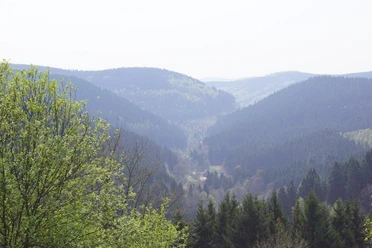
The Sieber valley under nature protection is the only large river valley in the western Harz that is not blocked by a dam.
Author´s Tip / Recommendation of the author
Natural monument "Dreibrodesteine," three oversized blocks of granite formed by spheroidal weathering.
Nature reserve "Siebertal" with diverse and special flora and fauna, shaped by former intensive mining use.
Safety guidelines
- In the area of the Eisensteinsberg, relics from mining times such as heaps and adits are noticeable. Exploring and entering is dangerous and prohibited. Strict path adherence is required in Harz National Park.
Nearby

Download GPX file