Circular trail around the cave village Rübeland (HWN 88 & 89)


- 1:40 h
- 5.06 km
- 151 m
- 159 m
- 378 m
- 467 m
- 89 m
- Start: Parking lot Mühlental in Rübeland
- Destination: Parking lot Mühlental in Rübeland
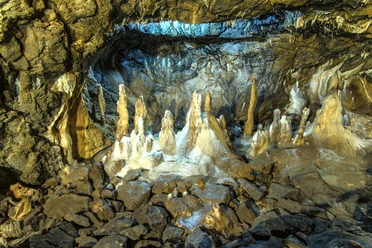
The circular hiking trail around the cave village of Rübeland runs along the rugged rock faces that surround the Harz village. Several great viewpoints invite you to linger. Discover fauna and flora on the family-friendly hiking trail. Unfortunately, the hiking trail is not suitable for strollers due to partly narrow and steep paths. Here, we recommend hiking with a child carrier. From April to October, admire the lively life of wild bees at the "Bee Bear" at Hoher Kleef and at the "Bee Miner" at Schornsteinberg, and you still have two stamps from the Harzer Wandernadel to collect. During the summer months, you can admire and enjoy the beautifully blooming mountain meadows. On the hiking route, you always have the Brocken in view. Many small rest points offer opportunities to linger. Last but not least, you should plan a cave visit to the Hermann’s or Baumann’s Cave. Or even both caves?
Good to know
Best to visit
Directions
Our hike starts at the "Mühlental" parking lot in the cave village of Rübeland. After about 400 m, you cross the street and pass over the railway and Bode bridges. At the end of the bridge, keep left and take the right street uphill at the road fork. After about 600 m, we recommend the small detour to the "Bell House". A narrow path leads over the meadows to the 410 m high viewpoint with views over Rübeland and towards the Brocken massif.
Back on the hiking trail, continue on the main path. After about 300 m, follow the signs to the left to the "Birkenfeld Castle Ruins". Old stone wall remains reveal the castle ruins. Information boards provide hints about the castle. Continue for about 400 m towards the "Hoher Kleef" viewing pavilion. Here you will find the stamp box (HWN 88). Additionally, you can enjoy a fantastic view of the Brocken directly from the pavilion, as well as a panoramic view of the cave village of Rübeland. Continue to the left and after about 100 m, you will encounter the Harzer-Hexen-Stieg and the "Bee Bear" with a seating area. The "Bienotel" is a life-sized carved bear that houses a bee colony in a species-appropriate dwelling inside its belly.
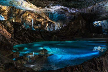
After a rest, we hike a stretch on the Harzer-Hexen-Stieg until we reach the L 96 at the height of Hermannshöhle. We recommend a visit to the "River Cave" with its unique grotto salamanders and sparkling crystal chamber. From there, cross the bridge around the Herzklippe with bear towards the railway crossing. After the railway crossing, cross the B27 and turn right towards the outdoor pool "Bodeperle".
During the summer months, a little refreshment at the outdoor pool is recommended. Afterwards, continue directly from the parking lot towards the Schornsteinberg, which is located directly above the outdoor pool.
A small, narrow path leads us behind a house to the Schornsteinberg. After about 300 m, we reach the Schornsteinberg via an ascent of about 80 meters in elevation, which rewards us with a fantastic view of Rübeland.
At Schornsteinberg is the stamp point 89 of the Harzer Wandernadel. The name of the mountain originates from the fact that the approximately 6 m high chimney of the carbonization plant was previously located here.
Continue on the "Blue Lake" circular trail towards the Baumann Cave over expansive mountain meadows and grasslands with a direct view of the Brocken. To conclude the hikes, another cave visit at the Baumann Cave invites before we reach our destination parking lot "Mühlental".
Equipment
Sturdy footwear and rain gear are recommended. Don't forget your Harzer Wandernadel stamp booklet and camera.
Directions & Parking facilities
You can reach Rübeland by car
- via the B27 from Braunlage and Blankenburg
- the B244 / B27 from Wernigerode
- as well as via the B81 junction L96 from Hasselfelde
Parking lot - Mühlental
Coming from Elbingerode, parking spaces for cars, motorcycles and caravans, fee required
Parking lot - Baumann Cave
Parking spaces for cars directly at the Baumann Cave, fee required
Parking lot - Hermann Cave (at the old train station - right side of the "Bode" river)
Coming from Hasselfelde, parking spaces for cars, fee required
Parking lot - At the "Bodeperle" outdoor pool
Coming from Blankenburg, parking spaces for cars, motorcycles and caravans, fee required
You can reach the cave village Rübeland by bus from the Harzer Verkehrsbetriebe:
from Wernigerode
from Blankenburg
from Hasselfelde
from Braunlage
from Benneckenstein
INSA - your public transport route planner for Saxony-Anhalt >>
TIP:
With the Harzer UrlaubsTicket you can travel free of charge throughout the Harz district.
HATIX - free use of the public bus lines of Harzer Verkehrsbetriebe, Q-Bus Nahverkehrsgesellschaft, Halberstädter Verkehrs-GmbH, and Verkehrsgesellschaft Südharz in the Harz district.
More information is available at: www.hatix.info
Additional information
Tourist Information Elbingerode/Cave village Rübeland/Königshütte
Markt 33 8875
Oberharz am Brocken OT Elbingerode
Phone: 039454 89487
Literature
Unfortunately, no literature is known.
Author´s Tip / Recommendation of the author
On this circular route, you have the opportunity to collect two sought-after stamps of the Harzer Wandernadel.
No. 88 - Viewing pavilion Hoher Kleef
No. 89 - Schornsteinberg
In summer, a visit to the Bodeperle outdoor pool is recommended after the hike.
The Rübeland dripstone caves are also particularly worth seeing.
The hiking route can also be hiked in reverse.
Safety guidelines
Not suitable for strollers or similar. We recommend the hike with a child carrier.
The ascent from the outdoor pool to Schornsteinberg is steep and only a "footpath". Keep a close hold on your children.
Map
Hiking map - City Oberharz am Brocken 1:25000; ISBN 978-3-86973-248-0
Nearby


Download GPX file