Natura Tip 9 - Brummtal near Quenstedt


- 1:45 h
- 6.64 km
- 39 m
- 103 m
- 148 m
- 233 m
- 85 m
- Start: Quenstedt
- Destination: Welbsleben

Good to know
Best to visit
- suitableDepends on weather
Directions
The starting point of our hike is Quenstedt. The town is the administrative center of the city of Arnstein, established in 2010, and is located on the B 180. Quenstedt is well accessible by public transport. At the southern edge of the town, the Harkeröder Weg branches off to the west. After almost 1 km, we reach the FFH area. The path leads down into the Brummtal, where, contrary to the flow direction of the Hengstbach, a path is signposted towards Schalkenburg. However, we follow the signposts towards Harkerode because our first hiking destination is the ruins of Arnstein Castle. The Brummtal is diverse. Our path initially passes through orchards, then a short section in the shade of overhanging poplar and locust tree branches, and finally along the Hengstbach on the right, lined with willows and alders. Elderberry and rowan grow on the meadows, which are no longer farmed.
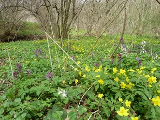
Shortly before our path crosses the stream, open pastureland begins, used by a shepherd with his animals. Then, the path lined with old cherry trees climbs the left slope of the Brummtal. At the junction to Sylda, we come across a meadow that extends up to a hilltop. There is a small outcrop there, like a window into earth history. The erosion edge is particularly species-rich (pasqueflower, saxifrage among others) and gives a hint of the botanical diversity that once characterized the area before nutrient deposits favored nitrogen-loving grasses. Back on the path, we follow the signposts towards Spitzbreite. We have covered 2 km, just passing under a 380 kV power line, until a narrower path crosses after another 200 m. We first take this path uphill and pass through an oak-hornbeam forest at the so-called Gerichtskopf.From the intersection to the castle ruins, we have another 1.5 km ahead and the same way back! Halfway, we can rest in the shade of a solitary chestnut tree and spot the EU bird sanctuary Hakel on the northern horizon. To the south, we look at Sylda. Westward, at the geodetic fixed point (233 m above sea level), the houses of Harkerode are visible in the valley in front of us. In the distance lie Ulzigerode and Wieserode. We are already in the Harz, but its more or less continuous forest area begins only behind Wieserode! First, a single winter lime tree on the left roadside, then field maple and ash on the right, and soon we walk along an avenue of Lombardy poplars. With our backs to the old orchard, we look across the Einetal valley towards the Rammelsberg. At the edge of the castle grounds, a tree gate made of two linden trees: on the left, the old summer lime with its velvety soft leaves and on the right, the smooth leaves of the mighty winter lime. The Geopark information board reveals background information on the history of the castle and the natural history of the diabase hill on which it sits. On the path branching off left before the tree gate, leading down to the lower castle, we find various semi-dry grassland communities with field scabious and meadow sage. Quickly back the 1.5 km to the intersection and fresh for the 2 km to the bus stop in Welbsleben, from where we can take the VGS-414 bus line back to Quenstedt until early afternoon (later on school days). Once more, the Hengstbach is dammed before it flows into the Eine. On the right of the Eine, we walk along a very typical oak-hornbeam forest. On the right, in an old quarry, we can see how thick the blown-in loess layer is.
Directions & Parking facilities
- Parking
At the gas station in Quenstedt.